The City in Bloom

Xio Alvarez, Trish Cafferkey, & Cynthia Hua

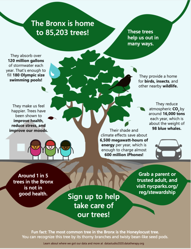
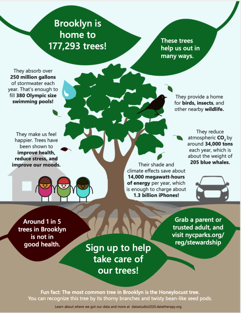
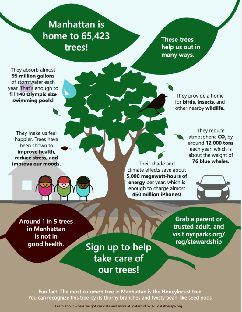
Our group chose to explore the New York City Tree Census data, which is collected and disseminated by the NYC Parks Department. In particular, we worked with the 2015 dataset.

The data say what types of trees have been planted all across the city, complete with locational data and species, presenting different tree-demographic profiles across the different neighborhoods. We thought that, with the addition of some more information about the qualitative character of the trees themselves, we could tell an interesting story about the way trees can impact the atmosphere of the city. We want to tell this story because we think that, while people may mostly notice trees when they are doing something like flowering or changing, their presence in a city, borough, or neighborhood can have outsized impacts on quality of life for their neighbors.

An all-city bloom

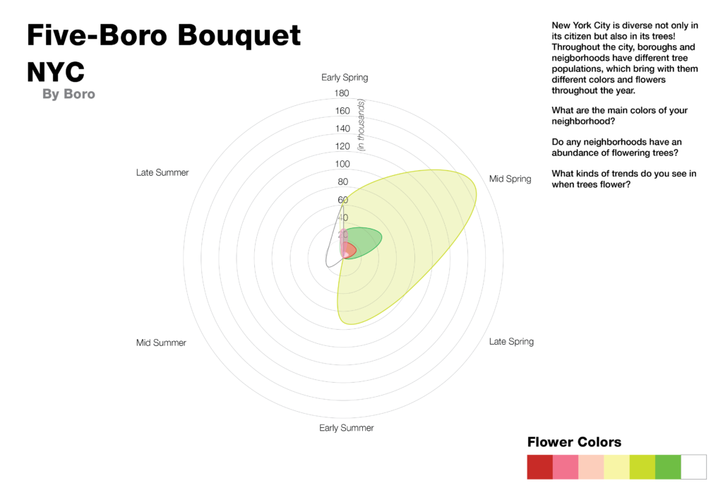
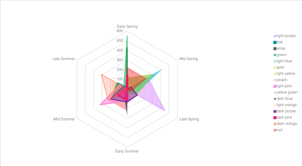
We joined the tree census data with a dataset from Plantium containing the times of year the trees (18 trees for this sketch) flower, and the color of the blooms. Charting this radially, we produced a series of jurisdictional “blooms” and “bouquets” which reflect the different plantings around the city, and when in the year they are at their peak bloom.

For our audience, we considered two sets of individuals with opposing sets of needs that might appreciate this type of service — those who chase flowers (tourists, photographers) and those who have allergies and might want to avoid them.

the Five-Boro blooms (a bouquet)
The Queens neighborhood bouquet

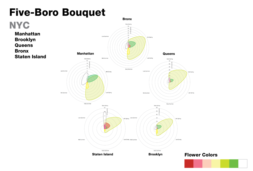
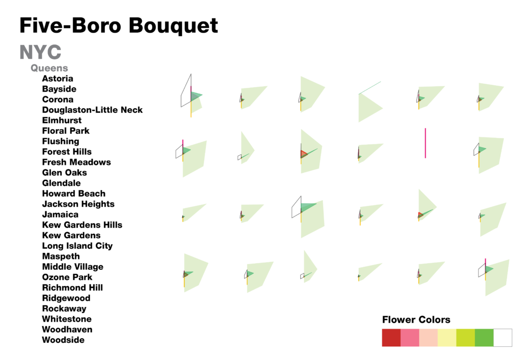
By looking at the neighborhoods and boros together, we can get a sense of the different character profiles of the flowering trees in the neighborhood. We can see which neigborhoods have more trees than others, and how some neighborhoods have irregular presentations over the course of a year.

As we designed this sketch, we realized that there were additional considerations we would need to account for if we wanted to move forward with a more complete story. With just this presentation of data, we would need to normalize for the area of the different jurisdictions, as right now they are all presented as though they have equal area, which does not support our story. Our sketch also stops at the neighborhood level, and we think it would be interesting to allow users to create a chart of their block or street. Finally, since the census is a regularly updated dataset (around every 5 years), we thought it would be interesting to include previous census years to show how the city’s blooms have changed over time.

An additional dataset we would be interested in including would be information on other flowering plants in the city, which would produce a more vibrant and extensive chart.

a mock up with more flowering plants

Trees In NYC: Sign Up To Help!

By: Claudia Chen, Eileen Hu, and Thiago Medaglia

The data say around 1 in 5 street trees in New York are in “fair” or “poor” condition (as opposed to “good” condition). We want to tell this story because children in the area can help improve these tree conditions by getting involved. We’ve chosen to tailor our message to middle school students in New York City in the form of a handout for them to take home. Information on the handout is tailored to each of 5 boroughs of NYC, with the goal of personalizing the graphic and allowing readers to see themselves in the data. With this, we hope students will sign up to help volunteer and improve tree conditions in NYC.

We started out by analyzing the 2015 NYC street tree census, which showed us how many street trees there are in NYC and the distribution across boroughs. The data also showed us that about 17% of trees (in NYC overall and in each borough) were evaluated as having fair or poor health (rather than good health). It also had a limited amount of data on the estimated number of stewards per tree which led us to the city’s Citizen Stewardship Program that encourages people to volunteer to care for, plant and learn about trees. We decided to tell the story of how trees help us and how we can help trees, from the perspective of the NYC Parks & Recreation Department.

This led us to look for data regarding tree impact in the city. Impact for each individual tree varies depending on tree species/maturity and there was no data available regarding total benefits for the current street trees in NYC by borough. However, we were able to find a dataset analyzing total benefits of street trees from 2005 data with detailed models. We used these total benefits and the total number of trees at the time to get the approximate average benefit per NYC street tree. Then we multiplied those averages by the actual number of trees in each borough and rounded the numbers to make them approachable. Finally, we contextualized the numbers using familiar objects, for example, converting megawatt hours to the number of fully charged iPhones. 

For this project, we paid more attention to the question of how to represent the benefits accurately and to make them more personal in terms of presentation rather than looking for surprising patterns within the original dataset. This led to some interesting challenges. We had to make choices regarding how much it was acceptable to round the numbers and what comparisons to make. For example, for “trees reduce CO2 by around x tons per each year”, we were considering using “x miles of car CO2 emissions” or “offsetting CO2 emissions from driving from the earth to the moon x times” rather than “weight of x blue whales”. We thought about how we wanted to represent the diversity of the city when putting in figures for the kids. We had to figure out how to balance putting in the cool facts we found vs keeping the infographic from getting cluttered. However, the whole process was instructive and interesting, and we even got to add in some symbolism with the idea of “1 in 5 trees is not in good health,” indicated by a dark brown leaf for every 1 in 5 leaves on the infographic. The smaller leaves were also designed to lead the reader through the infographic, pointing to the specific facts to read.

Sources

Specific borough and tree condition data:

https://data.cityofnewyork.us/Environment/2015-Street-Tree-Census-Tree-Data/pi5s-9p35

Impact per tree:

https://www.milliontreesnyc.org/downloads/pdf/nyc_mfra.pdf

Happiness from trees:

https://greatergood.berkeley.edu/article/item/why_trees_can_make_you_happier

Context conversions: 

https://www.livestrong.com/article/350103-measurements-for-an-olympic-size-swimming-pool/

https://en.wikipedia.org/wiki/Blue_whale

https://www.epa.gov/greenvehicles/greenhouse-gas-emissions-typical-passenger-vehicle

https://blogs.oracle.com/utilities/iphone-6-charging-47-cents